Catalyzing climate-health data use with the DHIS2 Climate App
With this new tool, countries like Uganda can easily explore, and import climate, weather, and environmental data sets into their existing DHIS2 systems and harmonize them with health data, helping overcome a common barrier to routine climate-health analysis.
One of the most significant barriers to the effective analysis of the impacts of climate change on health has come down to data. While routine health service and disease data is available in most countries, the widespread lack of digitized climate data–and the difference in granularity, time scale, and geographic format–has historically made it very difficult to analyze climate-health impacts without engaging in time-consuming and labor-intensive processes. This was the main lesson learned from the first DHIS2 climate and health pilot in Grenada in 2017, and was reinforced by a literature review by the HISP Centre at the University of Oslo (HISP UiO) at the start of our Wellcome-funded DHIS2 for Climate & Health project.
To address this challenge, HISP UiO developed the DHIS2 Climate App. This application makes it easy for countries to import climate, weather, and environmental data into their existing DHIS2 health information systems, and harmonize it automatically with their health data. Country-level stakeholders have been instrumental in the iterative development of the app, leading to the inclusion of additional data sets and aggregation options. The 10 countries involved in the DHIS2 for Climate & Health project have worked with national health programs to explore how the Climate App can support innovative climate-health analytics such as research-based suitability mapping for climate-sensitive diseases, predictive modeling products for vector-borne diseases like malaria and dengue, heat and air pollution risk mapping for non-communicable diseases, and exploration of climate impacts on malnutrition.
In describing the role of the Climate App in advancing the climate and health agenda at the country level, the HISP Uganda team has called it a “game changer” for how it has inspired engagement, contributed to research, and facilitated collaboration between health and meteorological stakeholders. In Uganda, the app fulfills some of the strategic objectives in the Uganda’s Health-National Adaptation Plan (H-NAP) related to the need for climate-health data integration, illustrating how it can provide all countries using DHIS2 with a key tool to help inform policy and programmatic decision making for climate change adaptation.
Lessons learned from an early DHIS2 climate and health pilot
In 2017, HISP UiO, climate and health experts from the WHO-WMO joint office on climate change and health, and GIZ worked with the Ministry of Health of Grenada on a DHIS2 climate and health pilot project. This was in response to findings from a 2015 risk assessment that warned of potential effects of climate change on the incidence of vector-borne communicable diseases such as Dengue, Chikungunya, and Zika. Prior to the pilot, the country’s disease surveillance program was paper-based and could not be easily combined with other datasets for analysis, making it challenging to rapidly identify disease outbreaks and mobilize a response.
The objective of this action research project was to design and assess how local health and climate (rainfall, temperature), and water and sanitation data could be registered at the facility and village/community level and integrated in DHIS2 to support early warning and adaptation, such as epidemiological analysis for dengue elimination. The joint project team convened local stakeholders to collaborate on the design of the system, including the National Water and Sewerage Authority, the Meteorological Office, the Land Use division of the Ministry of Agriculture, and the public health department of St George’s University. A technical working group was formed to coordinate the integration of disparate data sets.
Although this pilot project was never implemented at scale, the lessons from it have directly informed HISP’s current climate and health work: While health data were registered by health facilities, rainfall and temperature data were collected based on geographical points and areas, such as the name of a community or village or water catchment areas. The difficulty in harmonizing these disparate data sets made it clear that another approach was needed.
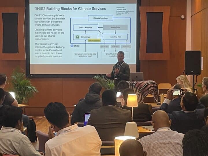
Developing the DHIS2 Climate App to address issues of data availability and harmonization
In addition to the lessons learned from Grenada, a climate and health literature review carried out by HISP UiO in the early stages of the project indicated that in many low- and middle-income countries (LMICs) the non-availability of digitized climate and weather data–even more than its spatial and temporal resolution–was a significant hurdle that would need to be overcome. In many LMICs, local weather stations are sparse and the majority are analog (with data recorded on paper). In addition, most national meteorological agencies do not have established agreements or platforms for sharing digital climate data freely with the Ministry of Health.
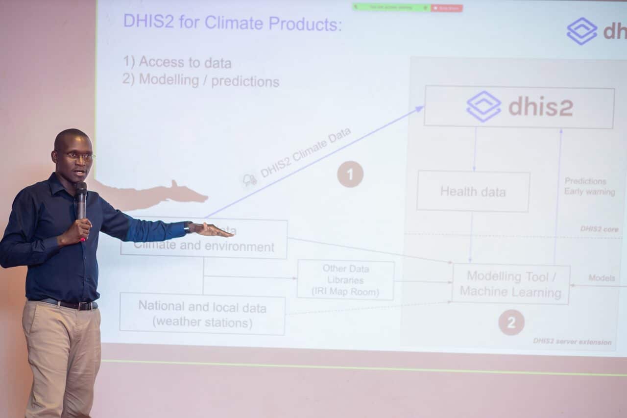
HISP UiO created the DHIS2 Climate App to solve some of these challenges, by making high-quality climate data available in DHIS2 systems in a format that could be easily combined with existing health data to facilitate combined climate-health analysis. To allow countries to get started quickly, we began by making the best global weather and climate datasets available, while also working in parallel on getting data sharing agreements between the national health ministry and the national meteorological office to make local weather data available in DHIS2. This also allowed us to make a generic solution that will work across multiple countries, using gridded datasets that can be aggregated to any health region and period represented in DHIS2. We also leveraged an existing agreement between HISP UiO and Google Earth Engine (GEE) that allows users of DHIS2 to utilize their powerful platform for non-commercial use. GEE provides both the datasets and the computing capacity to aggregate climate data to health regions (org units) in DHIS2.
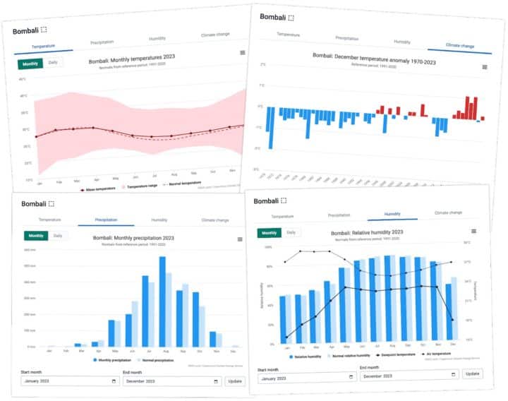
The Climate App allows DHIS2 users to explore and import weather and climate data for regions of their choice. That data is calculated on-the-fly on GEE and presented as different charts showing temperature, precipitation and relative humidity. The first dataset we focused on was ERA5-Land, which offers weather and climate data across 50 variables at 9 km resolution and at hourly intervals, and is widely considered to be the best climate data set available at global scale. We later added additional datasets, like CHIRPS precipitation data, which has a better resolution (around 5 km) and is often proven to be more accurate for many regions than ERA5 precipitation. ERA5-HEAT was added to provide the universal thermal climate index (UTCI), which is used for calculating heat stress, and additional data sets beyond climate–such as elevation and land cover–have been added based on input from country-level stakeholders.
Making global datasets available allowed us to kickstart our project with a generic solution. However, it is important to avoid a dichotomy between local and global weather and climate data. We need both, and they complement each other. Global products are required to fill the gaps when local data is missing. Seasonal forecasts need to build on global products, and local data can be used to increase the accuracy. Getting accurate weather and climate data for a region is a complex issue that requires expertise in meteorology and climatology–something that is outside the HISP network’s traditional area of focus. To address this, we have partnered with the International Research Institute for Climate and Society (IRI) at Columbia University, and continue to work in close collaboration with national meteorological offices to make local data available, and advocate for this data to be shared with WMO to improve global climate datasets, which will ultimately benefit country-level DHIS2 users.
Uganda’s experience with the Climate App: Developing innovative data products & providing valuable feedback
In Uganda, the Climate App has been a “game changer.” Previously, when HISP Uganda discussed potential uses of climate data in DHIS2 with national health programs, it was difficult to generate interest or concrete use cases. The Climate App made it easy to engage with health stakeholders, who can now easily see what is possible when climate data can be integrated with health data in DHIS2. It has also helped position HISP groups as key national stakeholders in the climate-health space, as it provided a tool for meaningful engagement with both state and non-state actors. In Uganda, this engagement has led to the development of three concrete climate and health use cases, particularly for Malaria suitability and risk mapping.
HISP Uganda began the process of introducing the Climate App in Uganda in April 2024, right after its initial release. They convened a stakeholder meeting with the Ministry of Health (MoH), the Ministry of Water and Environment, and the country offices of the WHO and the World Bank, among others. A live demo of the app created a lot of excitement. A follow-up meeting with the meteorological office and the MoH helped kick off discussions on a data-sharing agreement between these two government agencies, and this ongoing dialogue has also allowed the MET office a chance to validate the data in the Climate App, helping inspire a sense of ownership and buy-in. The Climate App was then installed on a Ugandan test instance of DHIS2 as well as in the national malaria data repository.
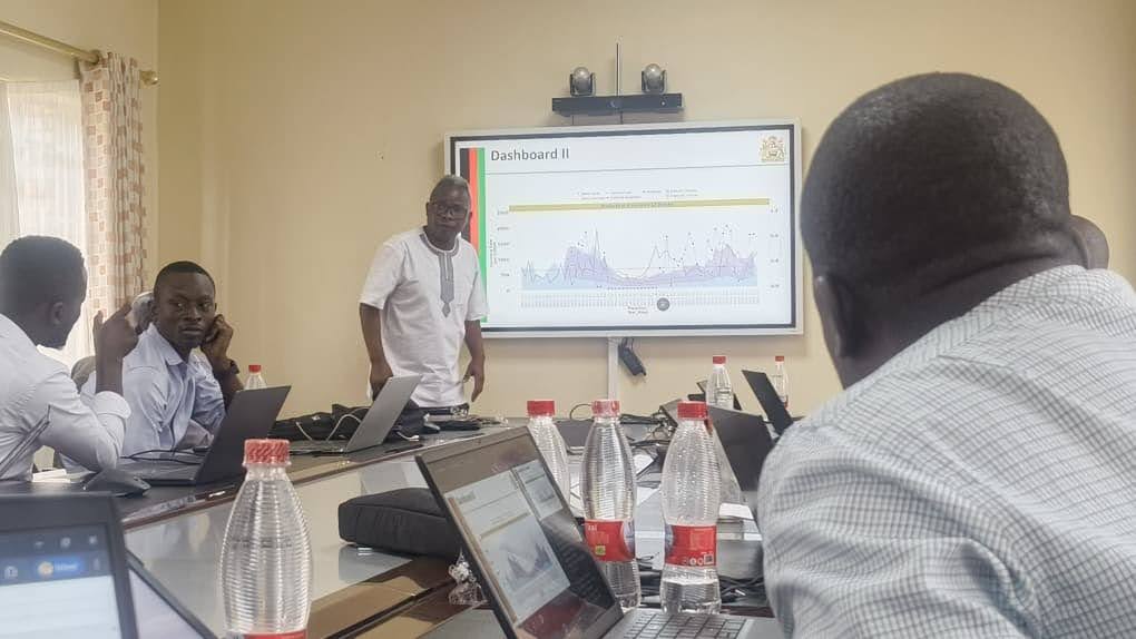
Through engagements with national health programs, HISP Uganda began developing tailored climate and health analytical products in DHIS2. With the malaria program, HISP Uganda began by adapting a risk mapping product based on peer-reviewed malaria research that was initially designed for the country’s Maproom platform–a system developed by IRI that produces customized climate services for different stakeholders, but which had not come into active operational use in Uganda due to various technical and organizational challenges.
Malaria prevention is a high priority for Uganda, as it ranked third globally in malaria burden, with an estimated 12.5 million cases, and malaria is a leading cause of death, particularly for children. The risk mapping tool uses precipitation, temperature, and relative humidity data (from ERA-5 and CHIRPS) to produce an indicator in DHIS2 that is visualized as a color-coded map showing geographical regions where the different conditions for malaria transmission are met. Having these outputs available directly in DHIS2 can facilitate targeted intervention planning, early warning of outbreaks, and risk communication.
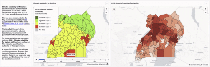
The process of testing and deploying this malaria suitability risk map in DHIS2 with stakeholders in Uganda’s national malaria program has generated valuable insights that have informed future versions of the DHIS2 Climate App. For example, it was noted that vegetation data was essential for accurately determining which regions were actually suitable for breeding the mosquitoes that carry malaria, as well as for other vector-borne diseases. This led to the addition of the Normalized Difference Vegetation Index (NDVI) dataset in the app, making it available in Uganda and all other countries using DHIS2. HISP Uganda also provided technical feedback on the app, leading to changes in how data is imported and the way in which certain graphs are configured, making the app more flexible and adaptable for different local contexts.
It has also inspired other HISP groups involved in the DHIS2 Climate &Health project to adapt HISP Uganda’s work on suitability mapping for their own context, such as HISP Ethiopia–an example of sharing of innovations across countries through the HISP network, and of climate-health capacity building between groups.
Supporting a variety of disease programs in Uganda and beyond
The deployment of the Climate App in Uganda has not stopped with malaria programs. NCDs are also an increasing public health burden in Uganda, accounting for approximately 40% of deaths. International research suggests that rising temperatures combined with air pollution are aggravating the negative health impacts of NCDs. To explore this climate-health use case, HISP Uganda partnered with Makerere University’s AirQo Project to integrate air quality data from 70 fixed monitors into DHIS2 using a custom app. Combining NCD data (Asthma and pulmonary disease) with air quality metrics and climate data (through the Climate App) facilitated exploratory analysis of potential climate and pollution-related health impacts.
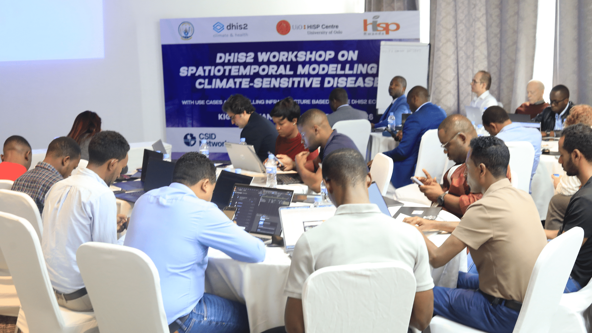
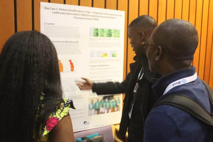
Innovation with the DHIS2 Climate App has not been limited to Uganda. The other 9 countries in the DHIS2 for Climate & Health project have also been actively working with the app through collaboration between HISP groups and local partners. Their projects have included development of a malaria stratification dashboard in Togo, analysis of climate impacts on malnutrition in Sri Lanka, and work on climate-informed early warning for dengue in Nepal, among others. The teams working on these projects meet regularly to share updates and ideas, which facilitates sharing of innovations and best practices between health programs and countries. This has also helped identify limitations and areas of improvement for the app, which has led to the addition of multi-calendar support (for Nepal and Ethiopia) and the incorporation of additional kinds of data, such as elevation.
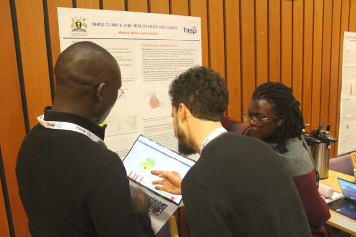
Each of the 10 countries presented updates on their projects in June 2025 at an internal climate and health conference in Oslo, as well as during the 2025 DHIS2 Annual Conference in poster format.
Enabling machine learning with climate and health data in DHIS2
Beyond traditional data analysis, integrating and harmonizing climate, weather, and environmental data with health data in DHIS2 has also made it easier for countries to begin leveraging machine learning and AI for predictive modeling of climate-sensitive health impacts. In Uganda, HISP Uganda has begun exploring predictive modeling for severe acute malnutrition (SAM), another area of health concern in their country, where 3 of 10 children suffer from undernutrition. This work has included developing a machine learning approach to transform data on population, malaria and pneumonia cases, historical SAM cases, lag variables, and seasonality into predictive intelligence.
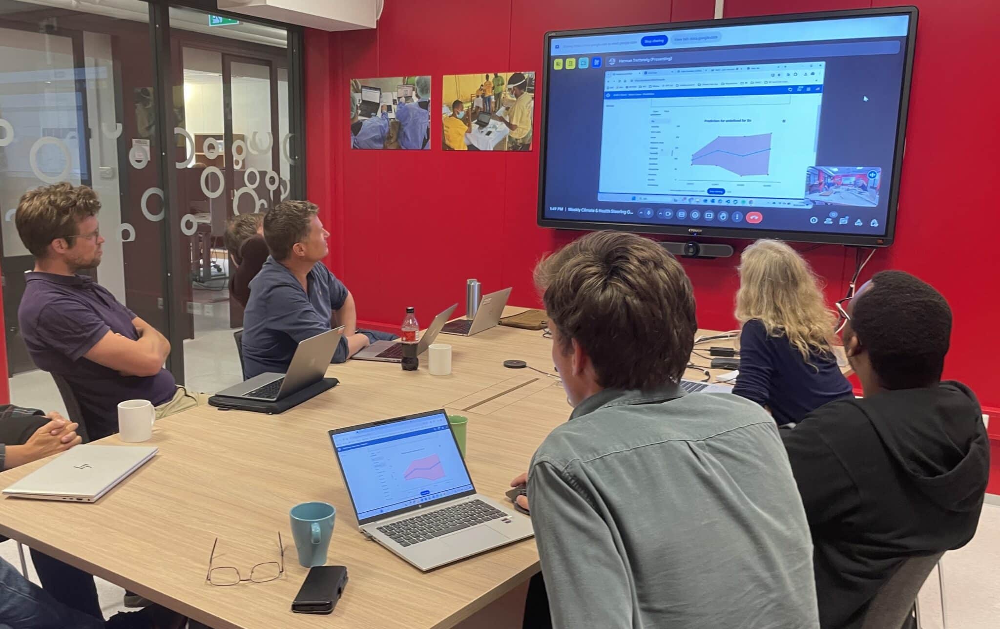
The use of DHIS2 for predictive modeling has been accelerated by the release of the Chap Modeling Platform, an open-source tool developed by HISP UiO that allows DHIS2 users to access, import, train, tune, run, assess, and share predictive models. This platform is model-agnostic, meaning that countries can use Chap to run their own models, and draw on a library of models shared by other experts. Chap connects seamlessly to DHIS2 via the DHIS2 Modeling App, which in turn draws on the DHIS2 Climate App for climate data import and harmonization.
HISP Uganda is in discussion with the team at HISP UiO about incorporating their work on SAM predictive modeling into Chap. They are also working with the national malaria program to plan a pilot of using the Climate App and Chap at the district level (first in 5 districts, later expanding to 15) for malaria suitability mapping and prediction of malaria cases. Working at the district level is particularly significant given that it is the districts that primarily manage malaria prevention interventions, and that are responsible for taking action in the event of an outbreak.
This kind of routine use of climate-health modeling outputs at the national and subnational levels has previously been impossible due to the labor and cost involved in bespoke modeling approaches and the difficulty of integrating outputs from siloed systems. Now, countries that use DHIS2 have powerful tools available to them that are already facilitating historical analysis of climate impacts on human health, and can soon make routine use of predictive analysis and forecasting of climate-sensitive health risks a reality.
Lessons learned and next steps
Since the DHIS2 Climate App was first released in April 2024, it has been downloaded and installed in a DHIS2 instance more than 4,000 times. This shows that there is a large amount of interest in integrating climate and environmental data into DHIS2 systems.
At the start of this project, it seemed like the use of “global” climate data in the Climate App might be a barrier to its adoption. However, this has generally not proven to be the case, thanks to a strategy of direct engagement and dialog with national met offices and other stakeholders. For example, HISP Uganda reports that involving the met office in the deployment of the Climate App has helped create a sense of ownership and a mandate to review and approve the data that is used, and has also created a greater appreciation of the value of global climate data products as a complement to local data. The availability of global data sets through the DHIS2 Climate App has helped move the conversation forward on sustainable approaches to digital climate data at a national level. HISP groups are actively working on a variety of context-specific solutions for incorporating local climate data into DHIS2–including through integration with established data sources such as IRI ENACTS–and developing a generic solution through the Climate App is a priority for HISP UiO in the coming months. Incorporating seasonal forecasts has also been identified as a key need.
Another lesson learned is how valuable the Climate App has been as a tool for climate-health research. In Uganda, the app has been very popular with students at Makerere University who want access to climate data for their health-related projects. HISP Uganda is planning to set up a DHIS2 instance for them, install the climate app, and train one person at the university to help them so that they can access this data on their own to support their research, much of which has focused on risk modeling, such as for malaria and other vector-borne diseases. Local research like this can play a key role in building climate-resilient health systems, as the findings can inform countries’ climate-health analytics outputs and models in DHIS2.
This brings us to a final lesson learned, which is that there is a steep learning curve for putting climate and health data to use. Many health stakeholders are unfamiliar with climate and weather data, and using it is not very straightforward. There is a need to raise awareness of existing literature on climate and health analysis, and to share best practices across countries. The HISP network is actively building climate-health capacity both within the network and with local stakeholders through engagement around the Climate app and Chap, and hopes to further support this by working with partners to develop and share guidance and toolkits to make it easier for countries to get started with climate and health for specific diseases and health programs.
Learn more about the DHIS2 Climate App with this presentation from the 2025 DHIS2 Annual Conference: