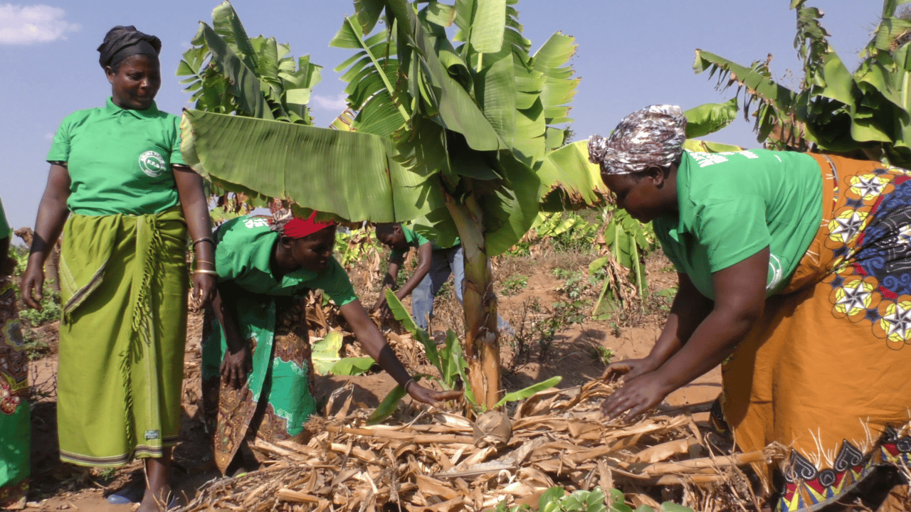
Malawi supports small-scale agriculture and promotes food security using climate data in DHIS2
A comprehensive, nationwide DHIS2-based management information system for agriculture harmonizes climate, demographic and agricultural data to improve food security in Malawi by supporting over 150,000 households
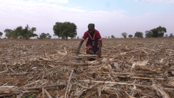
The economy of Malawi is largely driven by agriculture, which accounts for about 30% of the country’s GDP and up to 80% of its exports. As such, most households in the country engage in some form of agricultural activities both for subsistence and commerce. This is reflected in the National Agriculture Policy which stated that “Agriculture remains the mainstay of Malawi’s economy, contributing significantly to employment, economic growth, export earnings, poverty reduction, food security, and nutrition.” The country, therefore, set out to optimize agricultural inputs, processes and production by leveraging data from multiple sources to provide agriculture extension services, guidelines and essential information to farmers, as well as supplying planning data to policymakers and managers nationwide. This initiative is targeted at improving food security and agricultural productivity through sustainable data-supported practices. To achieve this objective, the Ministry of Agriculture (MoA) implemented a National Agricultural Management Information System (NAMIS) using the DHIS2 platform.
The NAMIS was developed with the support of a team at the University of Malawi, and builds on the country’s extensive experience gained from over a decade-long use of DHIS2 as a national Health Management Information System (HMIS) covering many health programs. The NAMIS system has also been extended to complement built-in DHIS2 functionalities by using custom applications that provide tailored reporting for M&E purposes and help the government of Malawi to deliver early warnings about weather events to farmers. Using the NAMIS, food situation assessments for individual households are routinely conducted and evaluated alongside projected production estimates of staple foods to facilitate effective food security planning in the country. Data generated in the system has also been utilized to direct resource allocation, improve capacity in small to medium-sized farms and promote local market integration for farmers.
Early warning, planning and action guidance through multi-stream data collection and analysis using DHIS2
The NAMIS receives climate and weather data from a nationwide array of weather stations managed by the MoA. Periodically, the Agricultural Extension Development Officers (AEDOs) collect the readings of the weather stations and enter the data into the NAMIS using specially configured tablet devices running a custom rainfall data collection tool. The same data is also shared with the Department of Climate Change and Meteorological Services (DCCMS) within the Ministry of Natural Resources and Climate Change by means of manual registers submitted monthly. The DCCMS relies on these records, data from other weather stations across the country and satellite data to collect and analyze statistics on rainfall, temperature, humidity and wind dynamics. The data are used to make projections and forecasts, which are shared as reports for specific periods like the 5-day; weekly; and seasonal weather forecasts. The data underlying these reports are shared with the MoA where it is then imported into the NAMIS and used to provide early warnings about weather events such as floods or droughts. The warnings are sent out to the farmers for necessary actions, like irrigation planning to safeguard their crops and maintain productivity levels. The data also helps the government plan special safety interventions like evacuations or large-scale irrigation which are beyond the capacities of individual households.
Malawi is one of Africa’s most susceptible countries to climate change, and agriculture in the country is often adversely affected by climate-related stressors such as droughts, floods, erratic rainfall and dry spells. Between 2018 and 2019, Malawi suffered crippling dry spells and damaging floods in different parts of the country resulting in a 15% decline in food production. These climate events, in addition to other socio-economic factors, are important to food security planning in Malawi, hence the need for reliable data-backed decision support systems. The Ministry of Agriculture (MoA) has developed the National Agriculture Management Information System (NAMIS) to provide a basis for data-backed decision-making. Some of the most prominent capabilities of the NAMIS are providing early warning on relevant weather and climate events and assessment of food security situations both for individual households and the country in general. The three-tiered early warning feature includes the following:
- Weather and climate events
- Household food situation assessment
- Agricultural production estimates
The registry is routinely updated during the bi-weekly rapid household food assessment, a community-based survey conducted by the AEDOs to collect information on staple foods held within each visited household to estimate the household food security status for the next fortnight. Consequently, the AEDOs rank the households based on established food security metrics and provide required advice to the household on the ideal course of action. An aggregate of these indicators collected throughout the country helps the MoA to estimate national food security status. The data, when combined with climate data, food storage information from the National Food Reserve Agency and food production estimates, help the MoA plan for enhanced disaster resilience and preparedness, thereby strengthening food security in the country.
Finally, the early warning component of the NAMIS also facilitates agricultural production estimation using relevant data such as the number of farmers benefiting from many agriculture support programs initiated by the government or NGOs. These programs include fertilizer subsidy programs, agriculture extension services, knowledge and capacity building initiatives, and programs to distribute enhanced drought-resistant seeds. When combined with data on crop types, farm sizes among others generated from estimate surveys, the MoA uses the NAMIS for agricultural production estimation, guiding planning and action at the national and sub-national levels.
Targeted community-level resource allocation and capacity development based on data-driven decision systems supported by the NAMIS
An important feature of DHIS2 is its capacity for drill-down reports up to the lowest organizational unit in the system. In the NAMIS, this means that the data collected in the system using the farmer registry in Tracker is granular enough to help the government plan interventions at the national, regional and household levels to improve food security and sustainable livelihoods. For example, more than half of the total irrigated areas in Malawi are utilized by small-scale farmers whose livelihoods were severely affected by the 2019 floods that damaged irrigation infrastructure. Also, over 4,000 hectares of arable land were lost to erosion and sand deposits associated with the flood. Significant damages were also done to other related agriculture infrastructures like canals, irrigation pumps and access roads. Leveraging DHIS2, the MoA can measure the impact of this large-scale disruption of agriculture on food security from the national scale down to the level of the individual farm.
To promote greater adoption of best agricultural practices in communities, AEDOs identify and follow up with model farmers known locally as lead farmers within each community. The lead farmers are elected individual farmers within communities who voluntarily assist the MoA to deliver up to three agricultural best practices or technologies to other farmers in order to increase yields and quality of crops. The lead farmers receive extensive training in the specific practices being promoted by stakeholders to boost productivity and improve efficiency. This practice strengthens agricultural extension, support services and research including improved crop trials and new technology adoptions. Though this practice predates the NAMIS, the adoption of Tracker for monitoring the initiative has helped the MoA increase lead farmer numbers, thereby further decentralizing access to agricultural extension services and promoting good practices across a larger number of communities.

Extending the NAMIS DHIS2 platform using custom applications for specific reporting and planning.
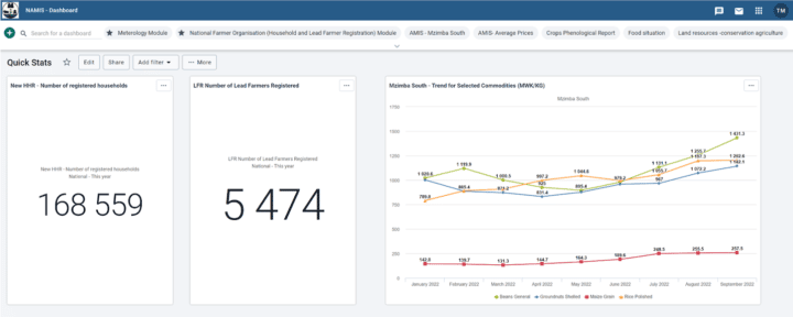
Using DHIS2, the NAMIS can generate many preset and ad-hoc reports and visualizations that strengthen M&E for various programs of the MoA by simplifying and decentralizing data collection and reporting. However, there are custom reports that are not easily implemented using built-in DHIS2 tools, such as the household food assessment and the agricultural production estimation reports, chiefly because they are calculated using a sample of the dataset populations. Currently, there are over 150,000 households registered in the NAMIS. To determine the national food security status of households in Malawi, a custom application developed and integrated into the DHIS2 platform extracts relevant data from a sample of the household population based on set criteria. The sample is subsequently analyzed to determine the desired indicator. Likewise, the agricultural production estimates for the country or specific districts are determined by sampling the farmer population for analysis.
Furthermore, the NAMIS is used to conduct a large number of surveys for different development planning programs. Reporting for some of these programs requires census data while others require sample data. To speed up the process of enrolling individual households into these programs, a custom application was developed. Some reports that are required by the MoH are in formats that are not easily generated in the NAMIS, thereby necessitating the extension of the system using additional custom applications.
The NAMIS system provides Malawi’s MoA with a comprehensive management information system for agriculture. The system helps the Ministry to collect a wide array of data on climate, weather, farmers and their practices into a central repository where they are analyzed and reported for early warning, planning and decision guidance. Other features of the NAMIS include a market information component, to promote local market integration for farmers, and a livestock information management tool. Further planned enhancements for the NAMIS include integration with Malawi’s national One Health platform to harmonize data from the HMIS, animal health and agricultural data into a single national health system based on DHIS2.
Watch a presentation on Malawi’s National Agriculture Management Information System from the 2022 DHIS2 Annual Conference: